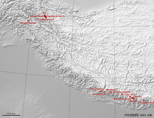
1. The world's highest peak: Mt. Everest--- Everest (8844.43 meters above sea level)
The Qomolangma (Everest) is located at the junction of Dingri and Tibet in the middle of the Himalayas in Tibet, China. It is the main peak of the Himalayas, also known as the Blessed Virgin Peak. The English name is Mt.Everest, geographical coordinates: longitude 86°55′31 , 27°59'17 north. The North Slope is in the Dingxiang County of the Tibet Autonomous Region of the People's Republic of China and the southern slope is in the Kingdom of Nepal.
Tibetan "Chumu" is the meaning of the goddess, "Rangma" is the third meaning, because there are four peaks near Mount Everest, Everest ranked third, "Qomolangma" means the third goddess. The name of Nepal is Sagarmatha, "the mother universe." In the "The Emperor's Map," compiled by the Qing Emperor Kangxi in 1956 (AD 1717), he called "Zhumulangmaaulin." The original 8845.13 meters above sea level, this data was measured by the first survey team of the State Bureau of Surveying and Mapping in 1966-1968 and 1975. In 1992, it was retested and confirmed to be 8844.43 meters above sea level.
The Mt. Everest mountain is a giant pyramid. It is majestic and powerful. The terrain is extremely dangerous and the environment is extremely complicated. The height of the snow line is 5800-6200 meters on the north slope and 5500-6100 meters on the south slope. There are three steep walls (north, east, and southwest) sandwiched between the northeastern ridge, southeast ridge, and west mountain ridge. Between these ridges and cliffs, there are 548 continental glaciers with a total area of ​​1457.07 km2. Up to 7260 meters. The supply of glaciers mainly depends on the formation of snowpack metamorphism in the two major precipitation belts of the Indian Ocean monsoon zone. On the glacier there are a variety of ice-tower forests, rare and magnificent, and there are up to tens of meters of ice cliffs and bright and dark ice cracks in step-by-step traps, as well as dangerous ice avalanche area.
2. The Second Highest Peak in the World: Qogir - Chogori (8611 meters above sea level)
The K2, also known as K2, is located on the Chinese side of Karakoram Mountain in the Yecheng County of Xinjiang Uygur Autonomous Region. It is the main peak of the Karakoram Ranges and the second highest peak in the world. It is also known as the K2 Peak. It is the border peak near the actual control area of ​​Pakistan in Xinjiang and Kashmir of Karakoram, geographical coordinates: longitude 76°30′51 east, 35°52′55 north latitude.
K2 Name Source: When the first visit to the Karakoram Ranges was made in 1856 by the British monk Montgomery, the five major peaks of the mountain range from west to east were marked with a “Kâ€. At the time, the Chogori Peak was marked K2. The one marked K1 is the 22nd peak of the world in northern Pakistan and the 11th peak of Mahablom in Pakistan.
"Qogori" is Tajik, meaning "tall and majestic." The Karakoram range is several kilometers dry and runs from northwest to southeast, with an elevation above 6000 meters. The peaks of the mountain range are dense, including the Chogori Peak, where four world-class peaks of more than 8,000 meters are lined up in close proximity. The east side of the Chogori mountain is the Buloat peak, 8051 meters above sea level; in turn there is the Kashulu Buluk mountain. , 8080 meters above sea level; Jiashuerbulmu I peak, 8028 meters above sea level. In the world, there are 14 peaks above 8,000 meters, accounting for nearly one-third of the total. There are more than 20 peaks above 7000 meters, and Skeiyang Kanli Peak on the north side, 7455 meters above sea level, Spand Peak on the west side, 7385 meters above sea level, and Coronet Peak down to 7295 meters above sea level. As a result, it became the second mountaineering center that the world’s mountaineers are eyeing.
The peaks of Chogori are pyramidal, with ice cliffs and steep mountains. On the steep slopes there are traces of avalanche chutes. At the top of the mountain is an ice slope that rises slightly from north to south. The north side is like a cutting ax, with an average slope of 45 degrees or more. There are mainly 6 ridges. The northwest and southeast ridges are the main ridge line of the Karakoram, and they are also the borders of China and Pakistan. Others include the northern ridge, western ridge, northwest ridge, and southwestern ridge. Peaks are pyramidal, ice cliffs stand, steep mountains. On the steep slopes there are traces of avalanche chutes. At the top of the mountain is an ice slope that rises slightly from north to south. The north side is like a cutting ax, with an average slope of 45° or more. The glacier on the north side is called the Qorgori Glacier, and the terrain is complex and changeable. The surface of the glacier is broken, and the cracks of light and dark ice criss-cross. The valley on the western side of the glacier is a steep rock wall with frequent rolling stones, ice sheets and avalanches. On both sides of the Chogori Peak, there is the 44-km-long Susuegeti glacier.
The area of ​​Chogori Peak is not only treacherous, but also has a terrible climate. From May to September each year, the southwest monsoon brings warm and humid air currents to rain, which is the rainy season in the region.
From mid-September to mid-April the following year, a strong west wind blew in and brought harsh winters. The minimum temperature of the peak is up to -50°C, and the maximum wind speed can reach 25m/s or more. It is the climate exclusion zone for climbing. Between May and September, due to rising temperatures, melting snow and precipitation, the water level in the valley often increases, making it difficult to enter the mountains. Therefore, the best time for mountaineering activities should be scheduled to enter the mountains in May and June, when the river is rising, However, it is not so serious; in July and September, the peak temperature is slightly higher and the good weather lasts longer. It is a good time for the summit.
3. The Third Highest Peak in the World: Kangchenjunga---Zhangjiafeng, Gancheng (Elevation 8586m)
Gancheng Zhangjiafeng ranks third among 14 peaks above 8,000 meters in the world. It is located on the border of Nepal and Sikkim kingdoms in the middle of the Himalayas. Its geographical coordinates are 88°09'01" east longitude and 27°42'09†north latitude.
The name of Gancheng Zhangjiafeng has the meaning of “Five Gods Snow Godâ€, and it comes from its five peaks. Although not as famous as Mount Everest, which is only more than 300 meters high, it was thought to be the world's highest peak before the world’s first peak was confirmed.
Ganchengzhangjiafeng is the main peak of a group of huge peaks. It is located in the center of three peaks with an altitude of more than 8,400 meters. There is the Yalankang Peak (8,438 meters above sea level) on the west side and the Qiancheng Zhangjia II Peak on the east side of the main peak. (8438 meters above sea level), the easternmost name is Darong Kangri Peak (8,476 meters above sea level). In the meantime, a number of valley glaciers have formed, making the mountains more dangerous, and ice avalanches and avalanches frequently appear.
Due to the control of warm and wet air in the Bay of Bengal, the precipitation is very large, and there is sufficient ice and snow supply. The Warm Glacier in Dongpo is 31 kilometers long and covers an area of ​​more than 130 square kilometers. Its thickness reaches 300 meters. There are Yalu glacier on the west slope, the dry city Zhangjia Glacier and the Prull Glacier on the northwest slope. These glaciers flow fast and there are more ice cracks. This group of peaks, affected by geographical location, is often densely covered and it is difficult to reveal the true colors.
4. The fourth highest peak in the world: Lhotse---Luozi Feng (85l6m above sea level)
Lhotse is located at the junction of Dingri and Tibet in the middle of the Himalayas in Tibet, China. It is 3 kilometers south of Mount Everest. They are separated by a mountain, which is commonly known as the "Nan." It is bordered by the north ridge of the mountain peak and the southeast mountain Ken. Its east side is in the territory of China's Tibet Autonomous Region and its west side is the Kingdom of Nepal. Geographical coordinates: longitude 86°90′ east longitude and 27°9′ north latitude.
Lhotse Mountain is 3km away from the “Southern Pass†next to Everest, so Lhotse is sometimes called the Southern Summit of Mount Everest. According to relevant international regulations, if the height difference (vertical height) between the two peaks exceeds 500 meters, they are considered as independent peaks. The low altitude of the “South Stream†between Everest and Lhotse is 610 meters above the height of Lhotse Peak, so Lhotse is an independent mountain.
Lhotse Peak Tibetan called it "Dingjie Association Sangma," which means "a beautiful fairy of blue color." This "fairy" terrain is extremely dangerous, the environment is extremely complicated, and the size of the glacier is very dense and the climate is unpredictable. The wind speed is slightly lower than the Mount Everest, but the rainfall is greater than Everest. Every year from early June to mid-September, heavy snowstorms and avalanches frequently occur, stirring up snow and fog. From mid-November to mid-February in the following year, the northwestern wind blows over the south to bring the temperature of the peak to -60°C. Only in the spring of the beginning of March to the end of May of each year, or the fall of early September to the end of October, the weather is relatively stable, and there may be several good weather conditions.
Lhotse’s majestic mountains are majestic and steep, with gigantic active glaciers, ice falls, and avalanches frequent. In particular, Camp 1 to Camp 1 are covered by millenarian hailstones and huge glaciers. The terrain is complex, the route is long, and the ice slope is large. There are countless immense ice cracks. Similarly, the camps No. 3 and No. 4 are also the most difficult roads to climb the Lhotse peak. There are frequent avalanches, and there are often large upper-air winds. The average snow depth is 60-65 cm, and the ice slope is 75. Degrees, up to 85 degrees in some locations. It has been learned that for more than half a century, there have been more than 300 foreign warriors who unfortunately have longed to sleep on this peak, and that local people have been regarded as a tiger.
5. The fifth highest peak in the world: Makalu--- Makalu (Elevation 8463 meters)
Makalu is located in the middle of the Himalayas. It is 24 km northwest of Mount Everest and borders on the northwest-southeast ridge. It is in the north of China's Dingri County in Tibet and the south is in Nepal. Geographical coordinates: longitude 87°06′ east, 27°54′ north latitude.
Mount Makalu has five main ridges, namely the northwestern ridge: the southwestern ridge, the northeast ridge, the southeastern ridge, and the northern ridge. The Weifeng on the north ridge is called Everest Peak and its altitude is 78l6 meters. The Weifeng Peak of the northwestern ridge is the Makalu 2 peak, which is 7640 meters above sea level. The southeastern ridge of Weifeng is slightly elevated at an altitude of 8010 meters. These peaks are covered with thick snow and ice. There are huge glaciers in the valleys, jagged cliffs and crevices on the glaciers, and ice avalanches are frequent.
6. The sixth highest peak in the world: ChoOyo - Zhuo Youyou Peak (8201 meters above sea level)
Cho Oyu is the sixth highest peak in the world. It stands in the middle of the Himalayas and is 100 kilometers east of the highest point of the Mt. Everest. It is on the north side in the territory of Dingri in the Tibet Autonomous Region of China and on the south side in the Kingdom of Nepal. The geographical coordinates are 86°66′ east longitude and 28°09′ north latitude.
Cho Oyu is also known as "Joe Ujah". “Zhuo'o Friends†means Tibetan in the “primary teacherâ€.
The Peak of Cho Oyu is a very large and gentle slope with a platform rather than a pyramid. It looks like a bald wise eld in the distance. Zhuo'ouyoufeng mainly consists of five ridges in the northwest, northeast, southwest, southeast, and west mountains. The north slope west ridge is a traditional climbing route. Its peaks are covered by snow all year round and numerous glaciers. The Gabral Glacier on the north side is more than 10 kilometers long, the Lamba Glacier on the south side is 14 kilometers long, and the Ghagba Glacier is more than 20 kilometers long. The type of glaciers is dominated by valley glaciers, followed by flat-top glaciers, ice glaciers and so on. Zhuo'ao Youfeng modern glaciers are well developed. At an elevation above 5,700 meters above sea level, it is the ablation zone in the middle and lower reaches of the Gabral Glacier. In this area, ice Tallinn is full of sight. The ice water melted from the ice tower is gathered into one glacial lake. Influenced by the glacial lake, a series of colorful ice ditch, ice cave and ice bridge are formed between the ice towers, which constitutes a world of ice, snow, and snow. Between 6900 and 7200 meters above sea level is the icefall area. As the mountains here are steep, the glaciers that hang on the mountains are like solid waterfalls. The momentum is spectacular, but it creates great difficulties for climbing.
The climate of the Cho Oyu area is complex and changeable. It is similar to the Everest, and it is dry and windy in the winter months. It is the dry season and the wind season. In the summer months, it is the rainy season and it is characterized by a continental plateau climate. In general, the rainy season starts from early June to mid-September, and the torrential rain brought by the strong southeast monsoon has caused frequent ice collapses and avalanches. This has caused the mountains and mountains to be filled with hazy weather. From mid-November to mid-February of the following year, due to the strong northwest cold current, the temperature can reach -60°C and the average temperature is between -40°C and -50°C.
The maximum wind speed can reach 90 meters/second. Only during the period from the end of April to the end of May, or from September to October, is the time when the windy season and the rainy season are transitioning to each other. There are often 3-4 times of good weather that lasts for 2 to 5 days. This is the time for climbing. The perfect time for the event, the best climbing season in the Himalayas, including Zhuo'ao, is spring, and the good weather cycle lasts for two weeks or so.
The climbing base of Cho Oyu can be reached directly by car, and a climbing cycle takes only about 6 weeks, plus a relatively simple route, so it is also considered to be one of the most easily climbable peaks of all 8000-meter peaks. . To date, more than 1,000 people have successfully reached the summit. At the same time, due to the relatively smooth and clear climbing route of Cho Oyu, there is almost no risk of ice avalanches. All of them are above the ridge, and there are few crosscuts. Therefore, this is also a paradise for mountaineering skiers.
7. The seventh highest peak in the world: Dhaulagiri - Dhaulagiri (8167 meters above sea level)
Dhaulagiri is located in Nepal, in the middle of the Himalayas, about 300 kilometers east of Mount Everest. Geographical coordinates: East longitude 83° 29′, north latitude 28° 41′. It is the westernmost position among several 8000-meter peaks in Nepal.
"Dorajiri" means "white mountain" in Nepali. It consists of limestone and dolomite forming the bottom rock layer. Because of the dangerous nature of the mountain, people are daunting, so it is called "Devil Peak." Nearby was carved into two peaks separated by the deep canyon of the Gandaki River, suddenly rising up around the terrain. The Dhaulagiri Peak Group and the Annapurna Peak Group are like two adjacent “Snow Mountain Family†and each have their own family “membersâ€. In the west, there are 6 peaks above 7,500 meters. The climate is changeable. The Ladrang Peak I at the peak of the peak is the "domestic" of the "Dow's" family, and echoes with the peak of Annapurna I, the tenth highest peak of the "Ange" family. Separating the two “heads†is Kali Gandaki, known as the deepest valley in the world. Two 8000-km peaks are located on the east and west sides of this valley, which is about 2,000 meters above sea level. The distance between the two peaks is only 38 kilometers.
From the beginning of April to the end of May, or from the beginning of September to the end of October, the spring and autumn seasons are suitable for the climbing season of Dhaulagiri.
8, the world's eighth highest point: Manaslu - Manaslu (8156 meters above sea level)
Manaslu is located in Nepal in the middle of the Himalayas. Geographical coordinates: longitude 84°33′ east longitude 28°33′ north latitude.
The Manaslu Peak, known by the Nepalese as the "disintegration", means "decoration piled up," and is considered as a mountain. Manaslu comes from the Sanskrit “Manasaâ€.
The peaks around Manaslu are surrounded by three peaks of more than 7,000 meters and many peaks of more than 6,000 meters. He is surrounded by numerous peaks and he is even more magnificent.
The Manaslu ridge has many slender ridges. The glaciers are densely distributed. The peaks resemble a sharp sword and are proudly erect. They are extremely dangerous. Climbing is extremely difficult. In the peak of 8000 meters, it is only located at the peak of Chogori, Annapurna and Nanga Parbat.
April, May and September and October of each year are suitable climbing seasons for Manaslu.
9, the world's ninth highest point: NangaParbat - Nanga Parbat (8126 meters above sea level)
Nampa Parbat is also known as Diamir. It is located in Pakistani Kashmir, the westernmost point of the Himalayas. 8126 meters above sea level. The geographical coordinates are longitude 74°6′ east longitude and 35°25′ north latitude.
Namga Parbat is the “naked mountain†in Urdu, Pakistan. Here is the world's largest rock wall, hence the name "Naked Peak", which is also known as "King of the Mountain".
The direction of Nampaparbat Peak is east-west arc. There are several ridges on the south and northwest sides of the main ridge line, mostly steep cliffs. There are dozens of glaciers in the valley. Its top is flat and covered with ice and snow all year round. Most of the glaciers in this area belong to oceanic glaciers and they move faster. They are affected by temperature and precipitation, and the steep terrain makes ice and avalanches very frequent.
People once thought that the Nanga Parbat was the most easily climbed 8000-meter peak, but it quickly paid the price for people's contempt. Before the first successful summit in 1953, 31 people had died for it. The climbing route of the Nanga Parbat is characterized by extremely unstable glaciers, frequent avalanches and violent blizzards; and its climbing season is also very brief, only between June and September.
10. The 10th highest point in the world: Annapurnaaka Morshiadi - Annapurna (8091 meters above sea level)
The Annapurna peak is located in the middle part of the Nepali kingdom in the middle of the Himalayas and north of the city of Pokhara in the Himalayas. Geographical coordinates: longitude 83°49′20 east, 28°35′45 north latitude.
55 km east of the Annapurna ridge is the Gandaki River, one of the deepest river canyons in the world. It cuts the faults in the Annapurna region. The surrounding peaks are clustered and the main peaks are Annapurna I (8091m), Annapurna II (7937m), Annapurna III (Annapurna III, 7555m), Annapurna IV. The peak (Annapurna IV, 7525m), Gangapurna (7455m), Annapurna South (7219m).
The peak of the Annapurna Range stands at seven, and there are seven peaks above 7000 meters above sea level. Near the main peak, the Matipucha Peak is famous for its sharpness. The scenery is magnificent. The fishtail peak of the southern margin splits into two peaks, resembling a fishtail, hence the name. Its peaks are steep and undisturbed. Although it is 6,607 meters above sea level, no one has reached the summit.
The climate in the Annapurna area is complex and changeable. It is roughly similar to Mount Everest, and due to the remote location of Annapurna, the route is hard and complex and can only be approached between September and October each year. The campsite at Anfeng No. 2 is a relatively dangerous area. It is in the recess of a huge ice wall. The snow on the ice wall is very dangerous for many years. There is a danger of slipping and falling down at any time. Only snow caves can be built. In the past, there were many foreign teams who would rather march long distances, cross or withdraw Camp No. 1 or stay overnight. Many people are here and have become the everlasting companion of Annapurna.
In the 20 years after the Annapurna summit was successfully launched in 1950, no one climbed again. The summit death rate of Annapurna is also among the highest among all 8000m peaks: By 2000, 106 people had reached the summit, but 54 climbers never woken up.
11. The eleventh highest peak in the world: Gasherbrum I—Gausblumm I Peak (at an elevation of 8,068 meters)
The peak I of Kashululom is the boundary of the actual control area of ​​Pakistan in Xinjiang, Kashmir and Kashmir. Geographical coordinates: longitude 76°41′48 east, 35°43′ north latitude.
The glacier peaks of the Ghaszlomb peak consist of rugged ridges, steps, and towering rock walls. It is the most remote group of mountains in the Karakoram Ranges, at the northwest end of the 36-mile-long Baltoroglacier. The peaks form a small circle that surrounds the South Gasherbrum Glacier. The peak consists of steep pyramidal rock masses composed of rugged ridges, steps, and towering rock walls.
Gasshobrum's “Gasherbrum†in the local language means “shinning? Wallâ€. This vividly illustrates that the peaks of the Kashulumu peak are covered with snow all year round. Flashing scene. The peak I of Kashulu Brom is also called “K5â€, which means the fifth independent main peak in the Karakoram Range. It is also the second highest peak of the Karakoram Range; because the location is high, it is not easy. Discovered, it is also known as "hidden peaks." It includes a total of six peaks, the highest peak of which is Gazechublom I. It is also known as the "Hidden Peak" (also known as K5) and was named by British Martin Conway in 1892. call. The mountain is tall, with a steep valley and a majestic shape that resembles a giant pyramid. There are two large glaciers in its Dongpo Gorge. There are many large and deep, criss-crossing light and dark ice cracks on the glaciers.
The peaks of Gakushulom I are treacherous, especially on the Chinese side where the terrain is complex and steep, ice avalanches are also frequent, and the climate is also very poor. To date, no one has yet been successful from the Dongpo. From May to September each year, the southwest monsoon brings warm and humid air currents to rain, which is the rainy season in the region. From mid-September to mid-April the following year, a strong west wind blew in and brought harsh winters. The minimum temperature of the peak is up to -50°C, and the maximum wind speed can reach 25m/s or more. It is the climate exclusion zone for climbing. Between May and September, due to rising temperatures, melting snow and precipitation, the water level in the valley often increases, making it difficult to enter the mountains. Therefore, the best time for mountaineering activities should be scheduled to enter the mountains in May and June, when the river is rising, However, it is not so serious; in July and September, the peak temperature is slightly higher and the good weather lasts longer. It is a good time for the summit. Its approach to the mountain is roughly the same as that of Chogori. After walking over the Gleida plate and entering the Kele Green Valley, it will then be folded eastwards for another 50 km to the southeast and will arrive at the Brak Mountaineering Base at an altitude of 4,250 metres.
12. The twelfth highest peak in the world: BroadPeak - Mount Brolot (8047m above sea level)
The Bloat Peak is located 12 kilometers southeast of the Chogori Peak and is the boundary of the actual control area of ​​Pakistan in the Karakorum Mountains in Xinjiang and Kashmir. Geographical coordinates: longitude 76°34′ east, 35°8′ north latitude.
The Bloat Peak is the third highest peak of the Karakoram Mountains. The mountain is full of mountains and snow. It has three main ridges: the north ridge, the ridge, and the southwestern ridge. The north and south ridges are the main ridgeline of the Karakoram and also the national boundary. On these two ridges are the central peak (8016m) and the north peak. (7538 meters), these three peaks are tall and straight, and they are tattooed. Therefore, the locals call it "Foluo Qinglai Gang", which means "Sanjian Mountain", and "Bloat" came from an American in 1892. The name of the expedition.
The Bloat Peak is majestic and its peaks are covered by snow and ice all year round. In addition, this mountain also has a huge rock wall. There have been many climbers trying to climb the southwest wall of the Bloat. This even includes such top masters as Kukuczka, but so far no one has been able to successfully climb the top from this direction.
13, the world's thirteenth peak: GasherbrumII---Gausboomm II peak (8034 meters above sea level)
The peak of Kashuluom II is the boundary peak of Pakistan’s actual control area in Xinjiang and Kashmir in the Karakoram Mountains, located on the main ridgeline of the Karakoram Mountains. Geographical coordinates: longitude 76°39'15 east, 35°45'31 north latitude, it is the fourth highest peak of the Karakoram range, and the boundary of Pakistan's actual control area in Kashmir. Among the four ridges of this peak are the northwestern ridges and the eastern ridges which are part of the main ridge line of the Karakoram Ranges, with the northern side in China and the south in Pakistan.
The Ghaszlomb II peak consists of a steep pyramidal rock mass composed of rugged ridges, steps and towering rock walls. “Gasherbrum†in the local language means “shinning wall†which vividly illustrates the snow-covered peaks of the Kashulumu group peaks, shining under the sun's rays.
The Ghaszloum II peak consists of six peaks, and the second peak of the Gauss-Brülm II peak. The peaks of the Gashur Bleu II peak are extremely important. The mountain is high and steep, and it is lined with clouds. There are four main peaks. Ridges: northwest ridge, southeast ridge, east ridge, southwest ridge. The northwest ridge and east ridge are part of the main ridge line of the Karakoram.
The peaks of the Gazebolom II peak form a small circle that surrounds the South Gasherbrum Glacier. On its steep rock wall, it is covered with ice and snow. The surrounding terrain is complex and changeable. Ice avalanches are very frequent, and its climate is similar to that of the Kashulumu I peak.
The peaks of the Gazebulu II peak are steep, the peaks are in the sky, and the steep slopes are covered in snow and ice. The terrain on the north side is particularly steep and complex, and the avalanche is frequent. It is extremely difficult to climb. Therefore, no one has been successful since the Chinese side. It was the first Austrians to conquer this record. They climbed the summit along the southwestern ridge on July 1, 1956.
14, the world's fourteenth peak: ShishaPangma - Xishabangma (8012 meters above sea level)
Xishabangma was formerly known as Gaoyan Zanfeng. It is located in the Nyalam County of Tibet in the middle of the Himalayas and 120 kilometers southeast of Mount Everest. It is an entire 8,000-meter-high peak in China. Geographical coordinates: longitude 85°46′55 east, 28°21′ north latitude. The Tibetan word “Shishabangma†means “Cold climate and bad weatherâ€, but the Tibetan people praise it as “Auspicious Mountainâ€.
Xishabangma is composed of three sister peaks with similar elevations, 200 meters northwest and 400 meters northwest of the main peak, with 8008 meters and 7,966 meters respectively. This is one of the centers of the modern glaciations of the Himalayas. The pylon area between 5000 and 5,800 meters above sea level is several kilometers long. The landscape is very strange, like the “ice crystal gardenâ€, but it is full of vertical and horizontal. Intertwined snow and ice cracks and occasional icy ice avalanches. The terrain on the northern slope of the Xishabangma is complex, steep mountains and ice cracks. Wild Bokanga Qin Glacier, like a Jade Dragonfly on the North Slope, has different shapes, meteorological conditions, clear and bright weather, warm and humid southern slopes, and 4700 meters of high altitude Rhododendron forest, and 3500 meters below pre-forest green. All kinds of precious animal habitats.
In May 1964, the Chinese team climbed the summit for the first time, setting a record in the world. At this point, the peaks above 8,000 meters in the world were all conquered by humans. The northern slope of the Xishabangma is a complex terrain with steep mountains and ice cracks. Ice avalanches and avalanches often occur. The largest wild Bokankang Qin Glacier on the North Slope is like a jade dragon in the foothills, and the ice tower forest is like a piece of scale armor. The southern slope of the Xishabangma is warm and humid. The altitude of the rhododendron forest is 4,700 meters above sea level. The green bamboo below 3,500 meters above sea level can be seen everywhere or in groups of precious sunbirds, long-tailed langurs and red pandas.
Make Up Brushes Kit,Makeup Brush Cleaner,Make Up Brush Cleanser,Cosmetics Foundation Brush
Guangzhou Yafei Makeup Toiletry Co.,Ltd , https://www.yfmakeupbrush.com